


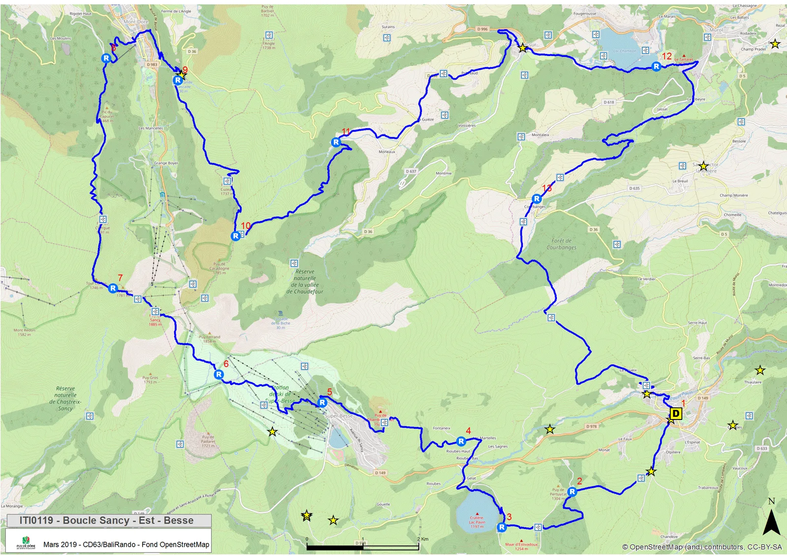
1/ Departure from Besse-et-Saint-Anastaise (Besse-en-Chandesse), Place de la Poterne near the tourist office. From the “Boucle du Sancy” sign, take the stairs under the porch of the Media Library. At the exit, turn left, cross Place de la Gayme towards the Belfry; pass under the porch, turn left and go up to the roundabout. Take the path opposite the sports hall and the war memorial. Continue straight ahead until you reach the road. Take it to the right for 200 m, then turn right (sculptures) on the path (180° view), towards Lake Pavin. Continue until you reach the entrance to a small wood at the La Lignère crossroads.
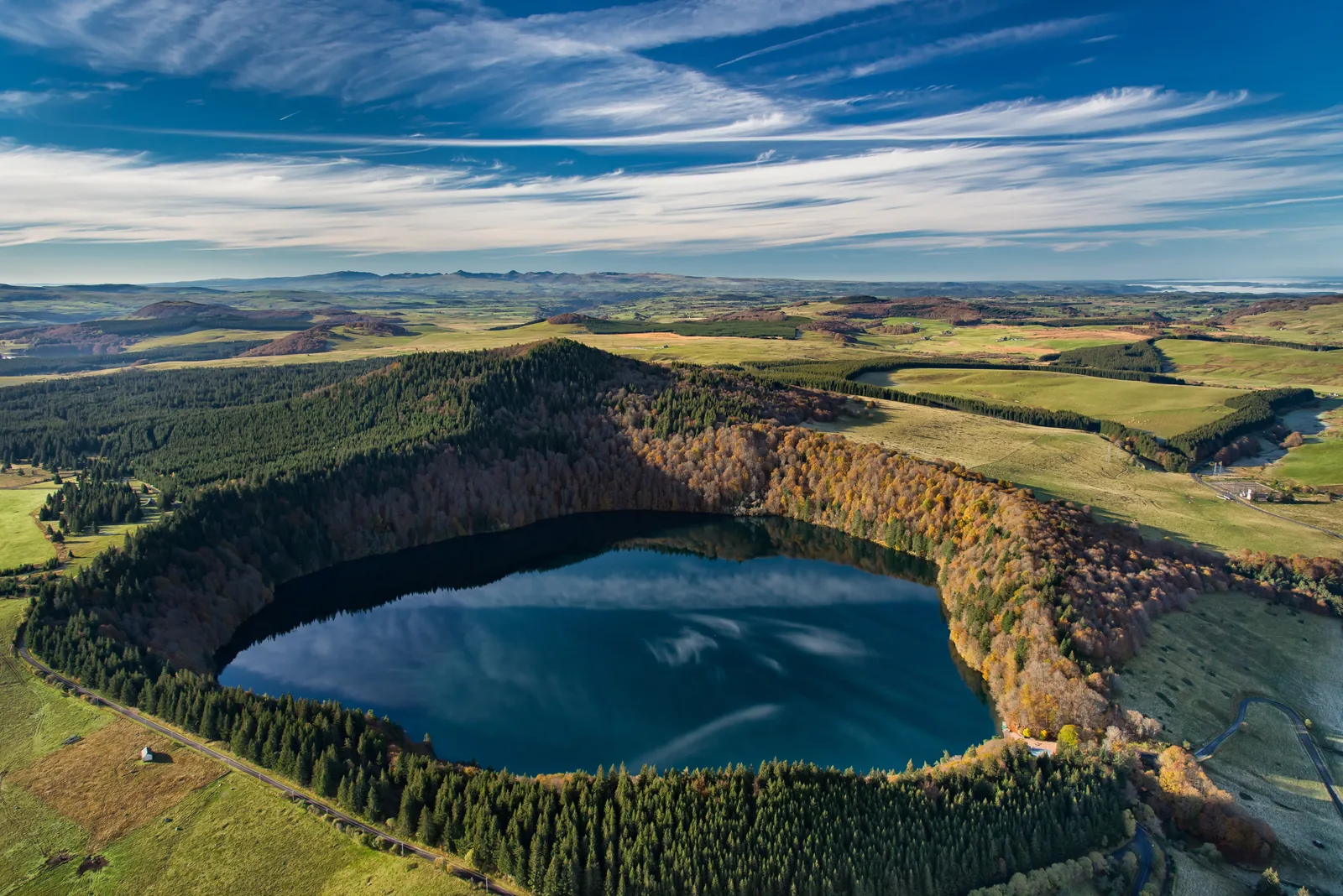
2/ Go up to the left, towards Pavin Lake, on the path entering the forest. Go to a crossroads of five paths in a clearing. Take immediately left, then right at the first fork. 50 m further, join another path which you take on the left. Continue on the grassy path and climb through the woods until you reach a wide forest path. Go up the path opposite and after 30 m turn left. At the first fork, stay on the right and continue straight on until you reach the road. Take it on the left then go down the first path on the right (view of the Estivadoux peat bog lake and the Puy de Montchal). Cross the pastures, pass two stepladders and continue on the grassy path between two fences up to the road (view of Lake Pavin 50 m on the left).
3/ Cross it and go right for 350 m on the path located between the road and the edge of the Pavin crater. At the hairpin, turn left towards Lake Pavin, then, 100 m further, turn right, direction Super-Besse, to reach the inn located on the edge of the lake. Go down the road on the left, cross the D 978, and continue on the road opposite. At the fork, go right, cross the D 149 and go up towards Fontaneix until the end of the straight line following the tight bend.
4/ Go left, direction Super-Besse, on a path bordered by two fences. Go up between pastures then at the edge of a wood and again between pastures until you reach a passage made of 2 wooden steps. Turn right, follow the wooden stakes, climb to the left in a small valley to reach a small flat area adjoining the scree of the Puy de Chambourguet. Go up to the left along the scree, pass the fence then go down (view of the Pavin and Bourdouze lakes, the Cézallier and the Cantal mountains) following it on the left until you reach a wide path. Take it down. At the T-junction, go up a wide path for 100 m then go down to the left via the ''Ponts de bois'' track extended by the ''Chemin de rond'' track. Go around the tower and go down between the ''La Falaise'' chairlift and the summer toboggan ski lift until you reach a crossroads.
5/ Go right on the path for 50 m. Go up to the right, direction Sancy, a path first parallel to the cable car then passing underneath. After the footbridge continue the climb, direction Puy de Sancy. Cross the ''Petits Cabris'' track and continue up a fairly steep slope under a chairlift. Turn left to go around a rocky bar then reach a plateau. On this, go up towards the cable car then gradually move away from it to the left. At the signpost for the ''Grive/Source'' slopes, continue to the right then left and reach the Col de Couhay. Continue climbing, to the right, on a wide path until the first intersection.
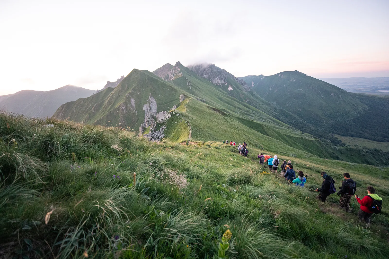
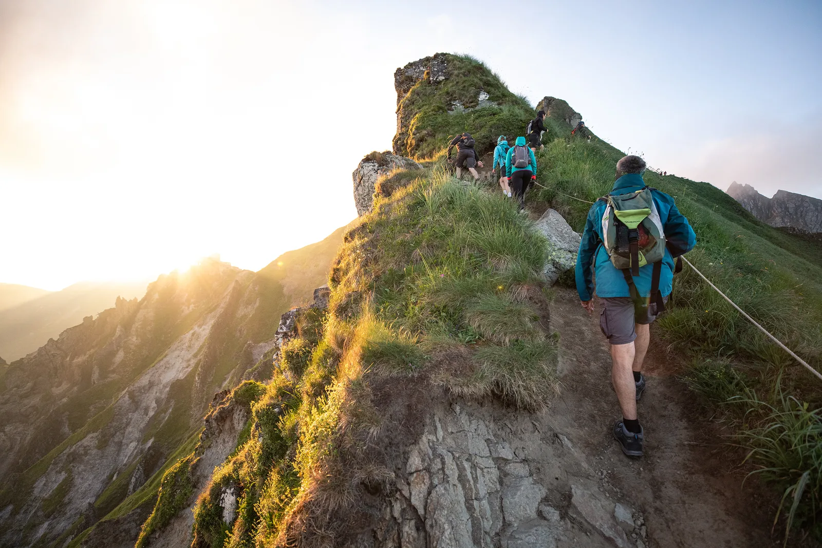
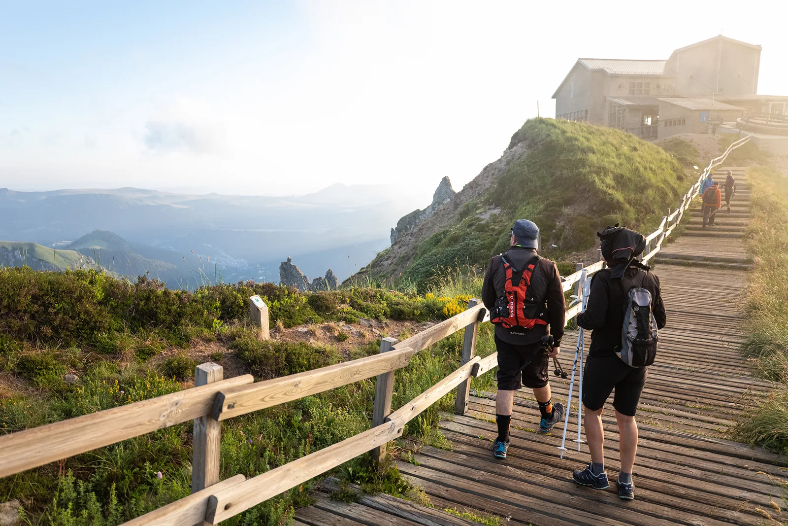
6/ Turn left towards Puy de Sancy. Reach the Col de la Cabane after leaving the Puy Gros on the left then overlooking the Cirque de la Fontaine Salée. Climb to the top of Puy de Sancy (orientation tables). Go down the stairs. At the Pas de l'Âne (view of the Cantal mountains and the waving organs), follow, on the left, towards Mont-Dore, Chastreix. After the stairs, go down a steep path on the left to the Col de Courre.
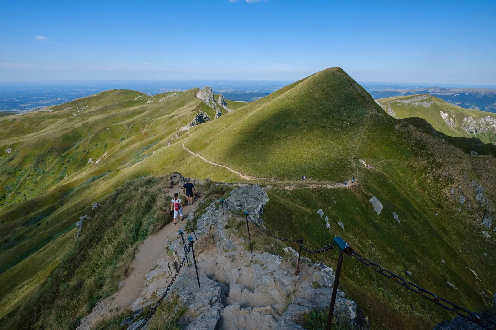
7/ Continue opposite, ignoring the side paths. Climb towards the Tour Carrée and continue on the ridges to the Puy de Cliergue (view of the Capucin, the Guéry plateau, the glacial valley of Mont-Dore). Go down towards the Capucin. At the quarry, continue right. At the Buron du Capucin, take the tarmac path to the Salon du Capucin car park.
8/ Go down to the right towards the arrival of the funicular, then turn left on the ''chemin des Mille Gouttes'' until you reach Avenue de la Libération at Mont-Dore. Join the Mont-Dore tourist office by going up this avenue, cross the park alongside the tourist office then cross the Dordogne. Take rue Perpère opposite and continue straight ahead. Go up the stairs (direction the waterfalls/Chemin de la Bane) to Chemin de Melchi Rose. Take it to the right. Cross a road and climb the winding path to the Grande Cascade. Continue via the footbridge to reach a grassy platform (view of Le Mont-Dore and the Dordogne valley).
9/ Cross it straight on and continue on the path obliquely (against the direction of the PR vert), continuing along a balcony above the Mont-Dore valley. Pass a stepladder and halfway up the slope of Roc de Cuzeau climb the path on the left to reach the summit (view of the glacial valley of Mont-Dore). Continue to Puy des Crebasses.
10/ Go left (view of the Chaudefour valley) and follow the path along the ridge. Continue downhill (two stepladders to cross), cross a grassy area straight ahead and continue on a path. At the entrance to a wood, go down to the left, cross a stepladder and follow the forest track to an inn in Chambon-des-Neiges.
11/ Walk along the parking lot. Take the first road on the left at the holiday village then take the first path on the right. At the crossroads, go up the left path and go right to the D 36. Turn left, follow the D636 for 1 km until you reach a cross path. Go right, along the edge of the woods, to the entrance to the hamlet of Angles. Cross the road then the hamlet, and go down towards the Serrette castle. Continue to the village of Chambon-sur-Lac. Turn right, cross the bridge then go left onto rue des Forges. After Place de la Fontaine, take rue Chez Chartoire opposite. Continue to the right of the church (Romanesque church and cross) to join the D996. Take it on the right for 30 m. Then turn right (campsite), continue straight, cross a bridge and continue to Murol beach at the south-east end of Lake Chambon.
12/ Continue opposite on the path after the inn. At the crossroads, continue straight on then take Chemin des Sables on the right. Go up to the first path on the left, go down it to the road. Turn right towards Jassat and, at the bend, take the path on the left and go opposite the campsite entrance. After the bridge go right. In the hamlet, at the crossroads (watering trough), take the small road on the right, then turn left before the bridge. Follow this wide path and go up opposite. Cross a bridge and continue climbing to the left. Take the steep path on the right which goes up towards Courbanges. Continue on the path and climb a path (view of the Chaudefour valley cirque and the Puy de Sancy) until the intersection with the D 36 in Courbanges.
13/ Cross the D 36 and go up the road opposite, straight on, up to a fork (view). Go down to the left, cross the stream, go up into the Courbanges forest. At the first intersection turn left, then right at the next fork. Cross the main avenue and go opposite. At the end of the forest, continue to the right between two fences and go down to the stream. Go back up opposite and cross the plateau (Forez, Cézallier and Sancy mountains). Join a wide path which you take to the right to reach a T-junction with a road at the entrance to the village of Leylavaux. Go down to the left, cross two hamlets (Le Clozel then La Bouay). After a bend, leave the road and go down a path to the right (view of Besse) reaching the hamlet of La Villetour. Go down to the trough (bread oven, thatched cottage), stay to the left. At the top of rue du Lavoir, cross the D36, go left then right and go up. At the STOP, turn right, go up then take the first street on the left. At Place Dr A. Pipet, head right and follow rue des Mercières opposite. Place de la Gayme turn left and, at the Media Library, take the porch (tourist office) to the square.
The route is not accessible while the Super-Besse ski area is open.
The Sancy ridges are accessible from mid-May. Find out in advance about access conditions from the Sancy tourist offices.
Bring good hiking shoes and warm clothing.
Recommendations from Nature Reserves:
“In order to protect the exceptional natural heritage, the national nature reserves of Chastreix-Sancy and the Chaudefour valley have specific regulations. Dogs are not allowed, even on a leash, except on GR® trails (red and white markings), and bivouac is prohibited. »
PLEASE NOTE – The list of accommodations is currently being updated.
2024-03-20
2024-05-15
Route details
Description
Departure – Besse-et-Saint-Anastaise (Besse-en-Chandesse).
Place de la Poterne near the tourist office.
1 – From the “Boucle du Sancy” sign, take the stairs under the porch of the Media Library. At the exit, turn left, cross Place de la Gayme towards the Belfry; pass under the porch, turn left and go up to the roundabout. Take the path opposite the sports hall and the war memorial. Continue straight ahead until you reach the road. Take it to the right for 200 m, then turn right (sculptures) on the path (180° view), towards Lake Pavin. Continue until you reach the entrance to a small wood at the La Lignère crossroads.
2 – Go up to the left, towards Lake Pavin, on the path entering the forest. Go to a crossroads of five paths in a clearing. Take immediately left, then right at the first fork. 50 m further, join another path which you take on the left. Continue on the grassy path and climb through the woods until you reach a wide forest path. Go up the path opposite and after 30 m turn left. At the first fork, stay on the right and continue straight on until you reach the road. Take it on the left then go down the first path on the right (view of the Estivadoux peat bog lake and the Puy de Montchal). Cross the pastures, pass two stepladders and continue on the grassy path between two fences up to the road (view of Lake Pavin 50 m on the left).
3 – Cross it and go to the right for 350 m on the path located between the road and the edge of the Pavin crater. At the hairpin, turn left towards Lac Pavin, then, 100 m further on, turn right, direction Super-Besse, to reach the inn located on the edge of the lake. Go down the road to the left, cross the D 978, and continue on the road opposite. At the fork, go right, cross the D 149 and climb towards Fontaneix until the end of the straight after the tight bend.
4 – Go left, direction Super-Besse, on a path bordered by two fences. Climb in this way between pastures then at the edge of a wood and again between pastures until you reach a passage made up of 2 wooden steps. Turn right, follow the wooden stakes, climb left in a small valley to reach a small flat area adjacent to the Puy de Chambourguet scree. Go up to the left along the scree, pass the fence then go down (view of the Pavin and Bourdouze lakes, the Cézallier and the Cantal mountains) following it to the left until you reach a wide path. Take it down. At the T-junction, go up a wide path for 100 m then descend to the left by the ''Ponts de bois'' track extended by that of the ''Chemin de ronde''. Go around the tower and go down between the ''La Falaise'' chairlift and the summer toboggan lift to a crossroads.
5 – Go right on the path for 50 m. Go up to the right, direction Sancy, a path first parallel to the gondola then passing below. After the footbridge continue the climb towards Puy de Sancy. Cross the ''Petits Cabris'' track and continue on a fairly steep slope under a chairlift. Turn left to go around a rocky bar then reach a plateau. On this one, go up in the direction of the gondola then gradually move away from it to the left. At the trail sign ''Grive/Source'', continue to the right then to the left and reach the Col de Couhay. Continue the climb, to the right, on a wide path to the first intersection.
6 – Turn left towards Puy de Sancy. Reach the Col de la Cabane after leaving the Puy Gros on the left then overhanging the Cirque de la Fontaine Salée. Climb to the top of the Puy de Sancy (orientation tables). Go down the stairs. At Pas de l'Âne (view of the Cantal mountains and the sheaf of organs), follow left in the direction of Mont-Dore, Chastreix. After the stairs, go down a steep path on the left to the Col de Courre.
7 – Continue opposite, ignoring the side paths. Climb towards the Tour Carrée and continue on the ridges to the Puy de Cliergue (view of the Capucin, the Guéry plateau, the glacial valley of Mont-Dore). Go down to the Capucin. At the quarry, continue to the right. At the Buron du Capucin, take the paved road to the Salon du Capucin car park.
8 – Go down to the right towards the arrival of the funicular, then take the ''Chemin des Mille Gouttes'' to the left as far as Avenue de la Liberation in Mont-Dore. Join the Mont-Dore tourist office by going up this avenue, cross the park along the tourist office then cross the Dordogne. Take rue Perpère opposite and continue straight ahead. Climb the stairs (towards the waterfalls/Chemin de la Bane) to Chemin de Melchi Rose. Take it to the right. Cross a road and climb the switchback path to the Grand Cascade. Continue by the footbridge to reach a grassy platform (view of Le Mont-Dore and the Dordogne valley).
9 – Cross it straight and continue on the oblique path (against the direction of the green PR), continue it on a balcony above the Mont-Dore valley. Pass a stepladder and halfway up the Roc de Cuzeau climb up the path to the left to reach the summit (view of the glacial valley of Mont-Dore). Continue to the Puy des Crebasses.
10 – Go left (view of the Chaudefour valley) and follow the path along the ridge. Continue the descent (two stepladders to cross), cross straight a grassy area and continue on a path. At the entrance to a wood, go down to the left, cross a stepladder and follow the forest track to an inn in Chambon-des-Neiges.
11 – Go along the car park. Take the first road on the left near the holiday village then take the first path on the right. At the crossroads, go up the left path and go right to the D 36. Turn left, follow the D636 for 1 km to a side path. Go right, on the edge of the wood, as far as the entrance to the hamlet of Les Angles. Cross the road then the hamlet, and descend towards the Château de Serrette. Continue to the village of Chambon-sur-Lac. Turn right, cross the bridge then go left rue des Forges. After Place de la Fontaine, take Rue Chez Chartoire opposite. Continue to the right of the church (Romanesque church and cross) to join the D996. Take it to the right for 30 m. Then turn right (camping), continue straight, cross a bridge and continue to Murol beach at the south-east end of Lake Chambon.
12 – Continue opposite on the path after the inn. At the crossroads, continue straight on then take Chemin des Sables on the right. Go up to the first path on the left, go down it to the road. Turn right towards Jassat and, at the bend, take the path on the left and go opposite the campsite entrance. After the bridge go right. In the hamlet, at the crossroads (watering trough), take the small road on the right, then turn left before the bridge. Follow this wide path and go up opposite. Cross a bridge and continue climbing to the left. Take the steep path on the right which goes up towards Courbanges. Continue on the path and climb a path (view of the Chaudefour valley cirque and the Puy de Sancy) until the intersection with the D 36 in Courbanges.
13 – Cross the D 36 and go up the road opposite, straight on, up to a fork (view). Go down to the left, cross the stream, go up into the Courbanges forest. At the first intersection turn left, then right at the next fork. Cross the main avenue and go opposite. At the end of the forest, continue to the right between two fences and go down to the stream. Go back up opposite and cross the plateau (Forez, Cézallier and Sancy mountains). Join a wide path which you take to the right to reach a T-junction with a road at the entrance to the village of Leylavaux. Go down to the left, cross two hamlets (Le Clozel then La Bouay). After a bend, leave the road and go down a path to the right (view of Besse) reaching the hamlet of La Villetour. Go down to the trough (bread oven, thatched cottage), stay to the left. At the top of rue du Lavoir, cross the D36, go left then right and go up. At the STOP, turn right, go up then take the first street on the left. At Place Dr A. Pipet, head right and follow rue des Mercières opposite. Place de la Gayme turn left and, at the Media Library, take the porch (tourist office) to the square.