


The Sancy ridges are accessible from mid-May. Find out in advance about access conditions from the Sancy tourist offices.
Bring good hiking shoes and warm clothing.
Recommendations from Nature Reserves:
“In order to protect the exceptional natural heritage, the national nature reserves of Chastreix-Sancy and the Chaudefour valley have specific regulations. Dogs are not allowed, even on a leash, except on GR® trails (red and white markings), and bivouac is prohibited. »
PLEASE NOTE – The list of accommodations is currently being updated.
2024-03-20
2024-05-15
1/ From the departure sign near the tourist office, avenue de la Libération, cross the park alongside the tourist office then crossing the Dordogne. Take rue Perpère opposite and continue straight ahead. Go up the stairs (direction the waterfalls/Chemin de la Bane) to Chemin de Melchi-Rose. Take it to the right. Cross a road and climb the winding path to the Grande Cascade. Continue via the footbridge to reach a grassy platform (views of Le Mont-Dore and the Dordogne valley).
2/ Cross it straight on and continue on the path obliquely (against the direction of the PR vert), continuing along a balcony above the Mont-Dore valley. Pass a stepladder and halfway up the Roc de Cuzeau, climb the path on the left to reach the summit (view of the glacial valley of Mont-Dore). Continue to Puy des Crebasses.
3/ Go left (view of the Chaudefour valley) and follow the path along the ridge. Continue downhill (2 stepladders to cross), cross a grassy area straight ahead and continue on a path. At the entrance to a wood, go down left, cross a stepladder and follow the forest track to an inn in Chambon-des-Neiges.
4/ Walk along the parking lot. Take the first road on the left at the holiday village then take the first path on the right. At the crossroads, go up the left path and go right to the D 36. Turn left, follow the D 636 for 1 km until you reach a cross path. Go right, along the edge of the woods, to the entrance to the hamlet of Angles. Cross the road then the hamlet, and go down towards the Serrette castle. Continue to the village of Chambon-sur-Lac. Turn right, cross the bridge then go left onto rue des Forges. After Place de la Fontaine, take rue Chez Chartoire opposite. Continue to the right of the church (Romanesque church and cross) to join the D 996. Take it on the right for 30 m. Then turn right (campsite), continue straight, cross a bridge and continue to Murol beach at the south-east end of Lake Chambon.
5/ Continue opposite on the path after the inn. At the crossroads, continue straight on then take Chemin des Sables on the right. Go up to the first path on the left, go down it to the road. Turn right towards Jassat and, at the bend, take the path on the left and go opposite the campsite entrance.
After the bridge, go right. In the hamlet, at the crossroads (watering trough), take the small road to the right, then turn left before the bridge. Follow this wide path and climb opposite. Cross a bridge and continue uphill to the left. Take the steep path on the right which climbs towards Courbanges. Continue on the path and climb a path (view of the cirque of the Chaudefour valley and the Puy de Sancy) until the junction with the D 36 in Courbanges.
6/ Cross the D 36 and go up the road opposite, straight on, up to a fork (viewpoint). Go down to the left, cross the stream, go up into the Courbanges forest. At the first intersection turn left, then right at the next fork. Cross the main avenue and go opposite. At the end of the forest, continue to the right between two fences and go down to the stream. Go back up opposite and cross the plateau (view of the Forez, Cézallier and Sancy mountains). Join a wide path which you take to the right to reach a T-junction with a road at the entrance to the village of Leylavaux. Go down to the left, cross two hamlets (Le Clozel then La Bouay). After a bend, leave the road and go down a path to the right (view of Besse) reaching the hamlet of La Villetour. Go down to the trough (bread oven, thatched cottage), stay to the left. Cross the D 36. Leave opposite then, at the first path, continue to the right, cross the bridge and go up to the road at the entrance to Besse. Take the street behind the square and take the walkway towards the city center. Turn left on rue des Consuls then right on place Alfred-Pipet and continue on rue des Mercières until place de la Gayme. Finally turn left onto rue de Notre-Dame until you arrive at the tourist office.
7/ From Place de la Poterne, from the Boucle Sancy sign, take the stairs under the porch of the media library. Turn left on rue Notre-Dame and cross place de la Gayme. Continue rue du Beffroi and go under the door. Then, turn left and take rue de l'Abbé-Blot until the roundabout. Take the path between the sports hall and the war memorial. Continue straight ahead until you reach the road. Take it to the right for 200 m, then turn right (sculptures) on the path (180° view), towards Lake Pavin. Continue until you reach the entrance to a small wood at the La Lignère crossroads. Arrival at the Pertuyzat wilderness resort.
8/ Go up to the left, towards Lake Pavin, on the path entering the forest. Go to a crossroads of 5 paths in a clearing. Take immediately left, then right at the first fork. 50 m further, join another path which you take on the left. Continue on the grassy path and climb through the woods until you reach a wide forest path. Go up the path opposite and after 30 m turn left. At the first fork, stay on the right and continue straight on until you reach the road. Take it on the left then go down the first path on the right (view of the Estivadoux peat bog lake and the Puy de Montchal). Cross the pastures, go over 2 stepladders and continue on the grassy path between 2 fences until you reach the road (view of Lake Pavin 50 m on the left).
9/ Cross it and go right for 350 m on the path located between the road and the edge of the Pavin crater. At the hairpin, turn left towards Lake Pavin, then, 100 m further, turn right, direction Super-Besse, to reach the inn located on the edge of the lake. Go down the road on the left, cross the D 978, and continue on the road opposite. At the fork, go right, cross the D 149 and go up towards Fontaneix until the end of the straight line following the tight bend.
10/ Go left, direction Super-Besse, on a path bordered by 2 fences. Go up between pastures then at the edge of a wood and again between pastures until you reach a passage made of 2 wooden steps. Turn right, follow the wooden stakes, climb to the left in a small valley to reach a small flat area adjoining the scree of the Puy de Chambourguet. Go up to the left along the scree, pass the fence then go down (view of the Pavin and Bourdouze lakes, the Cézallier and the Cantal mountains) following it on the left until you reach a wide path. Take it down. At the T-junction, go up a wide path for 100 m then go down to the left via the Ponts de bois track extended by the Chemin de ronde track. Go around the tower and go down between the La Falaise chairlift and the summer toboggan ski lift until you reach a crossroads.
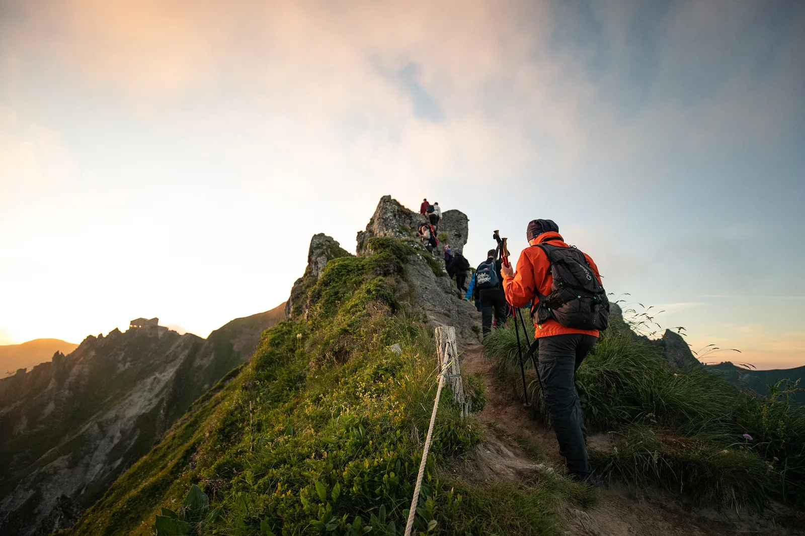
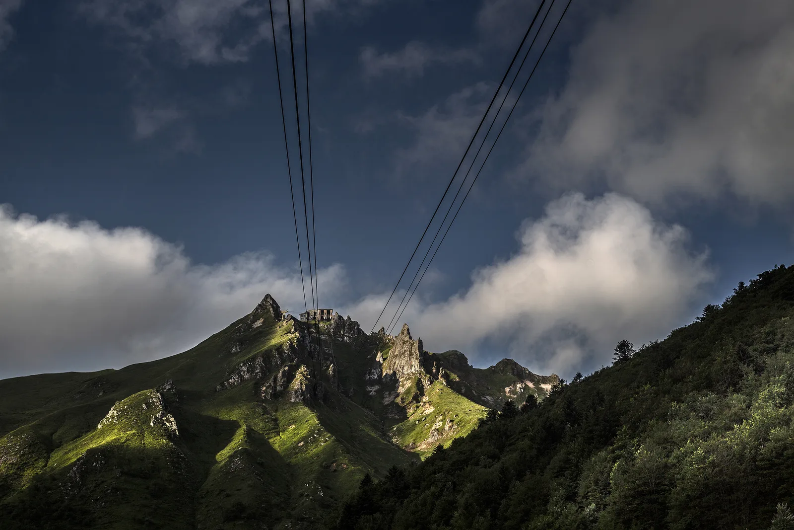
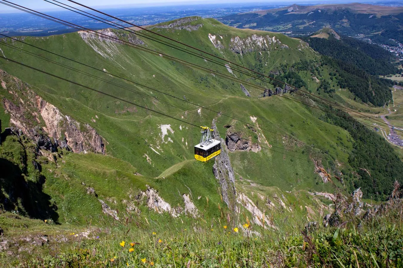
11/ Go right on the path for 50 m. Go up to the right, towards Le Sancy, a path first parallel to the cable car then passing underneath. After the footbridge continue the climb, direction Puy de Sancy. Cross the Petits Cabris piste and continue up a fairly steep slope under a chairlift. Turn left to go around a rocky bar then reach a plateau. On this, go up towards the cable car then gradually move away from it to the left. At the signpost for the Grive/Source slopes, continue to the right then left and reach the Col de Couhay. Continue climbing, to the right, on a wide path until the first intersection.
12/ Turn left (viewpoint) towards Puy de Sancy. Reach the Col de la Cabane after leaving the Puy Gros on the left then overlooking the Cirque de la Fontaine Salée. Climb to the top of Puy de Sancy (orientation tables). Go down the stairs. At Pas de l'Âne (view of the Cantal mountains and the organs), follow left towards Le Mont-Dore, Chastreix. After the stairs, go down a steep path on the left to the Col de Courre.
13/ Turn left then immediately take another left on a path progressing above the Cirque de la Fontaine Salée. At the intersection located on a shoulder, go down to the right towards the pylons of 2 ski lifts then follow the La Chambasse slope. At the arrival of a ski lift, continue the descent on the right and continue on a wide stony path passing under the ski lifts then emerging onto a road. Take it on the right and cross Chastreix-Sancy. At the end of a large right turn, go down the path on the right. At the crossroads, take the left path towards Chastreix. At the exit of the forest, pass a barrier and continue 50 m until you reach a grassy path.
14/ Go down it to the right towards Chastreix and after 300 m take a better path on the left. Cross the pastures. Cross a barrier and go down to an intersection.
15/ Go down the path on the right. At the road, go up the path on the right. Continue in the forest until you reach a second road (D 88) which you take on the left for 200 m. Turn right towards La Pinderie (view of the Roc de Courlande, Chastreix-Sancy and the Chambourguet mountain in the distance. To see: cross and trough). Cross the village. Go opposite on a large stone path becoming grassy. Continue and go down to a T intersection. Turn left then immediately right. Cross a stream then the meadow opposite. Join a path coming from the houses. Cross the bridge over the Jarrige stream then turn left. Follow the stream until the end of the field.
16/ Go up the path on the right. Enter the woods through a metal gate. Go up, ignoring the side paths. At the top of the hill, take the path on the right. Cross a stream, join the D 88 road, cross it, go up opposite it. At the wide path, turn left, continue, then go left again. Cross the car park and turn right onto a wide path. Further left, go down a grassy path. Follow it through the forest until you reach the Les 4 Départements crossroads. Go to the right, always continue as close as possible to the road, then further, go down to the parking lot
roadside spike. Head right along the car park to the Montagne de la Roche forest road on the left.
17/ Take it, and, 100m in, go up a wide path on the right. Follow it, ignoring the side paths, until you reach a clearing (Stèle cabin). Continue opposite and go straight on until La Charbonnière. Walk alongside the houses (view of Sancy, Roche-Vendeix, Puy Gros, Banne d'Ordanche). At the T-junction go left towards Charlannes. At the intersection after the top of a hill, go down on a forest track. Take the first path on the right and go down opposite the next two intersections. Join a forest track, follow it to the left and go straight on to Charlannes (information panels).
18/ Head right towards La Bourboule, leaving the reception area (old funicular) on the left and go down a winding path. Go around the middle station of the old funicular on the left. At 30 m, turn right and continue downhill until above the first houses. Take the overhanging path to the right, pass under the funicular track and reach a footbridge. Cross it and go left into Parc Fenestre. Follow the main path, pass to the left of a pond and walk alongside the old funicular station. At the exit of the park, continue opposite, pass in front of the town hall, cross the bridge over the Dordogne, walk alongside the thermal establishment and turn right onto Boulevard Clémenceau. At the church, turn right, cross the bridge and go up towards Parc Fenestre until you reach Montée de la Charreyre on the left.
19/ Take it and, at the flat area, turn left, go behind the wash house and go up Chemin de Fenestre on the right. After the end of the road, continue straight (view of the Dordogne valley, Puy Gros, Banne d'Ordanche). At the entrance to Prégnoux, go down the road on the left. In a bend, follow the path on the right and go down the first path on the left. Cross a stream and turn immediately right. After 50 m, go down left to the road. Cross it, cross the bridge over the Dordogne and take a path on the right that runs along the river. Cross the railway line and go up to the village of Genestoux.
20/ Turn right between the houses then left for 10 m, before going down right towards the river. Cross the bridge (Félix source) and continue to go up the river on the path which runs alongside the railway line. Go back up and continue the path which crosses the river at the Compissade mill. Go along then cross the river again via a wooden footbridge. Cross a small road at the Pont du Marais and continue until you reach a tarmac road crossing the Dordogne again. Pass in front of the gendarmerie and continue straight on rue des Chasseurs Alpins then avenue de la Gare. At the T-junction, continue right for 100 m and go down the stairs on the right. Cross the square and go down right towards the station. Pass in front of the station and continue straight on until the crossroads.
21/ Take the tarmac path to the left. At the fork, go left towards the city center. At the roundabout turn right (rue Sidoine-Apollinaire) and turn left in front of the hospital then right (rue Meynadier). Pass the casino then immediately turn right. Go up to the crossroads, turn left and reach the tourist office below on the left.
Route details
Description
D – From the Mont-Dore departure sign, cross the park alongside the tourist office then crossing the Dordogne. Take rue Perpère opposite and continue straight ahead. Go up the stairs (direction the waterfalls/Chemin de la Bane) to Chemin de Melchi-Rose. Take it to the right. Cross a road and climb the winding path to the Grande Cascade. Continue via the footbridge to reach a grassy platform (views of Le Mont-Dore and the Dordogne valley).
1 – Cross it straight on and continue on the path obliquely (against the direction of the PR vert), continuing along a balcony above the Mont-Dore valley. Pass a stepladder and halfway up the slope of Roc de Cuzeau, climb the path on the left to reach the summit (view of the glacial valley of Mont-Dore). Continue to Puy des Crebasses.
2 – Go left (view of the Chaudefour valley) and follow the path along the ridge. Continue downhill (2 stepladders to cross), cross a grassy area straight ahead and continue on a path. At the entrance to a wood, go down left, cross a stepladder and follow the forest track to an inn in Chambon-des-Neiges.
3 – Walk along the parking lot. Take the first road on the left at the holiday village then take the first path on the right. At the crossroads, go up the left path and go right to the D 36. Turn left, follow the D 636 for 1 km until you reach a cross path. Go right, along the edge of the woods, to the entrance to the hamlet of Angles. Cross the road then the hamlet, and go down towards the Serrette castle. Continue to the village of Chambon-sur-Lac. Turn right, cross the bridge then go left onto rue des Forges. After Place de la Fontaine, take rue Chez Chartoire opposite. Continue to the right of the church (Romanesque church and cross) to join the D 996. Take it on the right for 30 m. Then turn right (campsite), continue straight, cross a bridge and continue to Murol beach at the south-east end of Lake Chambon.
4 – Continue opposite on the path after the inn. At the crossroads, continue straight on then take Chemin des Sables on the right. Go up to the first path on the left, go down it to the road. Turn right towards Jassat and, at the bend, take the path on the left and go opposite the campsite entrance.
After the bridge, go right. In the hamlet, at the crossroads (watering trough), take the small road to the right, then turn left before the bridge. Follow this wide path and climb opposite. Cross a bridge and continue uphill to the left. Take the steep path on the right which climbs towards Courbanges. Continue on the path and climb a path (view of the cirque of the Chaudefour valley and the Puy de Sancy) until the junction with the D 36 in Courbanges.
5 – Cross the D 36 and go up the road opposite, straight on, up to a fork (viewpoint). Go down to the left, cross the stream, go up into the Courbanges forest. At the first intersection turn left, then right at the next fork. Cross the main avenue and go opposite. At the end of the forest, continue to the right between two fences and go down to the stream. Go back up opposite and cross the plateau (view of the Forez, Cézallier and Sancy mountains). Join a wide path which you take to the right to reach a T-junction with a road at the entrance to the village of Leylavaux. Go down to the left, cross two hamlets (Le Clozel then La Bouay). After a bend, leave the road and go down a path to the right (view of Besse) reaching the hamlet of La Villetour. Go down to the trough (bread oven, thatched cottage), stay to the left. Cross the D 36. Leave opposite then, at the first path, continue to the right, cross the bridge and go up to the road at the entrance to Besse. Take the street behind the square and take the walkway towards the city center. Turn left on rue des Consuls then right on place Alfred-Pipet and continue on rue des Mercières until place de la Gayme. Finally turn left onto rue de Notre-Dame until you arrive at the tourist office.
6 – From Place de la Poterne, from the Boucle Sancy sign, take the stairs under the porch of the media library. Turn left on rue Notre-Dame and cross place de la Gayme. Continue rue du Beffroi and go under the door. Then, turn left and take rue de l'Abbé-Blot until the roundabout. Take the path between the sports hall and the war memorial. Continue straight ahead until you reach the road. Take it to the right for 200 m, then turn right (sculptures) on the path (180° view), towards Lake Pavin. Continue until you reach the entrance to a small wood at the La Lignère crossroads. Arrival at the Pertuyzat wilderness resort.
7 – Climb to the left, towards Lac Pavin, on the path entering the forest. Go to a crossroads of 5 paths in a clearing. Take an immediate left, then right at the first fork. 50 m further, join another path that you take on the left. Continue on the grassy path and climb through the woods to a wide forest path. Climb the path opposite and 30 m turn left. At the first fork, keep to the right and continue straight on to the road. Take it to the left then go down the first path on the right (view of the Estivadoux bog lake and the Puy de Montchal). Cross the pastures, pass 2 stepladders and continue on the grassy path between 2 fences to the road (view of Lac Pavin 50 m on the left).
8 – Cross it and go right for 350 m on the path located between the road and the edge of the Pavin crater. At the hairpin, turn left towards Lake Pavin, then, 100 m further, turn right, direction Super-Besse, to reach the inn located on the edge of the lake. Go down the road on the left, cross the D 978, and continue on the road opposite. At the fork, go right, cross the D 149 and go up towards Fontaneix until the end of the straight line following the tight bend.
9 – Go left, direction Super-Besse, on a path bordered by 2 fences. Go up between pastures then at the edge of a wood and again between pastures until you reach a passage made of 2 wooden steps. Turn right, follow the wooden stakes, climb to the left in a small valley to reach a small flat area adjoining the scree of the Puy de Chambourguet. Go up to the left along the scree, pass the fence then go down (view of the Pavin and Bourdouze lakes, the Cézallier and the Cantal mountains) following it on the left until you reach a wide path. Take it down. At the T-junction, go up a wide path for 100 m then go down to the left via the Ponts de bois track extended by the Chemin de ronde track. Go around the tower and go down between the La Falaise chairlift and the summer toboggan ski lift until you reach a crossroads.
10 – Go right on the path for 50 m. Go up to the right, towards Le Sancy, a path first parallel to the cable car then passing underneath. After the footbridge continue the climb, direction Puy de Sancy. Cross the Petits Cabris piste and continue up a fairly steep slope under a chairlift. Turn left to go around a rocky bar then reach a plateau. On this, go up towards the cable car then gradually move away from it to the left. At the signpost for the Grive/Source slopes, continue to the right then left and reach the Col de Couhay. Continue climbing, to the right, on a wide path until the first intersection.
11 – Turn left (viewpoint) towards Puy de Sancy. Reach the Col de la Cabane after leaving the Puy Gros on the left then overlooking the Cirque de la Fontaine Salée. Climb to the top of Puy de Sancy (orientation tables). Go down the stairs. At Pas de l'Âne (view of the Cantal mountains and the organs), follow left towards Le Mont-Dore, Chastreix. After the stairs, go down a steep path on the left to the Col de Courre.
12 – Turn left then immediately take another left on a path progressing above the Cirque de la Fontaine Salée. At the intersection located on a shoulder, go down to the right towards the pylons of 2 ski lifts then follow the La Chambasse slope. At the arrival of a ski lift, continue the descent on the right and continue on a wide stony path passing under the ski lifts then emerging onto a road. Take it on the right and cross Chastreix-Sancy. At the end of a large right turn, go down the path on the right. At the crossroads, take the left path towards Chastreix. At the exit of the forest, pass a barrier and continue 50 m until you reach a grassy path.
13 – Go down it to the right towards Chastreix and after 300 m take a better path on the left. Cross the pastures. Cross a barrier and go down to an intersection.
14 – Go down the path on the right. At the road, go up the path on the right. Continue in the forest until you reach a second road (D 88) which you take on the left for 200 m. Turn right towards La Pinderie (view of the Roc de Courlande, Chastreix-Sancy and the Chambourguet mountain in the distance. To see: cross and trough). Cross the village. Go opposite on a large stone path becoming grassy. Continue and go down to a T intersection. Turn left then immediately right. Cross a stream then the meadow opposite. Join a path coming from the houses. Cross the bridge over the Jarrige stream then turn left. Follow the stream until the end of the field.
15 – Go up the path on the right. Enter the woods through a metal barrier. Go up, ignoring the side paths. At the top of the hill, take the path on the right. Cross a stream, join the D 88 road, cross it, go up opposite it. At the wide path, turn left, continue, then go left again. Cross the car park and turn right onto a wide path. Further left, go down a grassy path. Follow it through the forest until you reach the Les 4 Départements crossroads. Go to the right, always continue as close as possible to the road, then further, go down to the parking lot
roadside spike. Head right along the car park to the Montagne de la Roche forest road on the left.
16 – Take it, and, 100m in, go up a wide path on the right. Follow it, ignoring the side paths, until you reach a clearing (Stèle cabin). Continue opposite and go straight on until La Charbonnière. Walk alongside the houses (view of Sancy, Roche-Vendeix, Puy Gros, Banne d'Ordanche). At the T-junction go left towards Charlannes. At the intersection after the top of a hill, go down on a forest track. Take the first path on the right and go down opposite the next two intersections. Join a forest track, follow it to the left and go straight on to Charlannes (information panels).
17 – Head right towards La Bourboule, leaving the reception area (old funicular) on the left and go down a winding path. Go around the middle station of the old funicular on the left. At 30 m, turn right and continue downhill until above the first houses. Take the overhanging path to the right, pass under the funicular track and reach a footbridge. Cross it and go left into Parc Fenestre. Follow the main path, pass to the left of a pond and walk alongside the old funicular station. At the exit of the park, continue opposite, pass in front of the town hall, cross the bridge over the Dordogne, walk alongside the thermal establishment and turn right onto Boulevard Clémenceau. At the church, turn right, cross the bridge and go up towards Parc Fenestre until you reach the Montée de la Charreyre on the left.
18 – Take it and, at the flat area, turn left, pass behind the wash house and go up Chemin de Fenestre on the right. After the end of the road, continue straight (view of the Dordogne valley, Puy Gros, Banne d'Ordanche). At the entrance to Prégnoux, go down the road on the left. In a bend, follow the path on the right and go down the first path on the left. Cross a stream and turn immediately right. After 50 m, go down left to the road. Cross it, cross the bridge over the Dordogne and take a path on the right that runs along the river. Cross the railway line and go up to the village of Genestoux.
19 – Turn right between the houses then left for 10 m, before going down right towards the river. Cross the bridge (Félix source) and continue to go up the river on the path which runs alongside the railway line. Go back up and continue the path which crosses the river at the Compissade mill. Go along then cross the river again via a wooden footbridge. Cross a small road at the Pont du Marais and continue until you reach a tarmac road crossing the Dordogne again. Pass in front of the gendarmerie and continue straight on rue des Chasseurs Alpins then avenue de la Gare. At the T-junction, continue right for 100 m and go down the stairs on the right. Cross the square and go down right towards the station. Pass in front of the station and continue straight on until the crossroads.
20 – Take the tarmac path to the left. At the fork, go left towards the city center. At the roundabout turn right (rue Sidoine-Apollinaire) and turn left in front of the hospital then right (rue Meynadier). Pass the casino then immediately turn right. Go up to the crossroads, turn left and reach the tourist office below on the left.